Causes of Flooding and Flood Mapping Viewer
Worcester is already impacted by flooding each year for a variety of reasons. Climate change is causing an increase in both frequency and magnitude of precipitation events, causing localized flooding issues to intensify and/or spread to other areas. When it rains, water runs off impervious surfaces such as sidewalks, roofs, and roadways, getting dirtier as it goes, and eventually runs off into a storm drain and then directly to our rivers and lakes.
Flooding in Worcester is exacerbated by the:
Historic and current land uses:
- Close to 25% of the city’s landscape is impervious, made up of roads, parking lots and building roofs; water runoff from these impervious surfaces burdens pipes conveying that water.
- Many soils are compacted, limiting their ability to absorb rain.
- Historically, industry and development was in the floodplain along rivers and streams.
- Hilly topography results in numerous local low points.
Weather-related:
- Rapid-onset floods, known as flash or high-intensity floods, produce too much water, too fast for the storm water systems to take in or the ground to absorb; such floods are expected to increase due to climate change.
- Excessive rain or snowmelt cannot be absorbed into frozen ground.
- Typically, in the spring, rivers and lakes overflow from excessive rain or snowmelt.
Infrastructure issues:
- Waterways become blocked with debris or ice, and, consequently, overflow.
- Storm water systems break causing widespread flooding.
- Storm water systems built decades ago aren’t sized for the amount of water the city receives or the amount of impervious surfaces that drain to them and subsequently overflow during storms.
- Combined Sewer System: The treatment and pumping capacity of the pumping station is frequently exceeded during wet weather events, forcing storm water runoff and sanitary sewer water, combined, to be released into the nearby Blackstone River.
To assess flood vulnerability of your property, explore the map of reported and potential future flood events in Worcester (see the flood mapping viewer below) and click here to learn more about FEMA flood insurance.
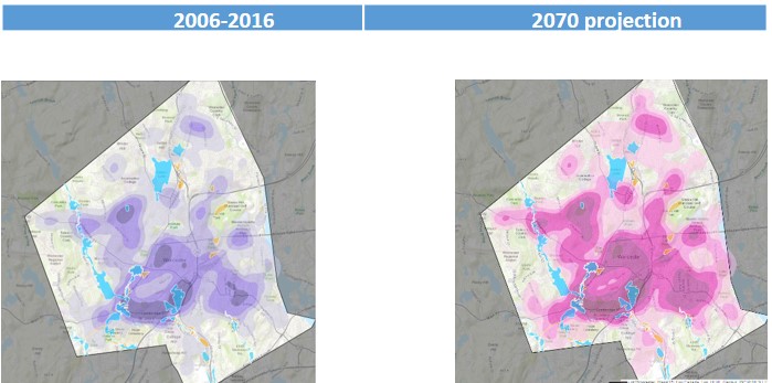
The Worcester Flood Mapping Viewer
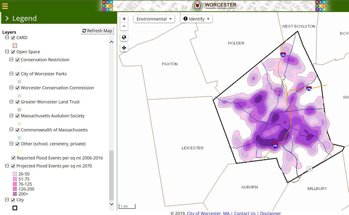
Explore the map of reported and potential future flood events in Worcester, as exacerbated by the effects of climate change!
The Worcester Flood Mapping Viewer has been developed as an informational tool for the Worcester community to consider and work to mitigate climate change threats from flooding.
The current flood events map (in purple) is based on the aggregate data the city has from reported localized flooding events collected via the city’s Customer Service Request System (CSRS), over a 10-year period: 2006-2016. The CSRS data was not derived through hydraulic or hydrologic modeling and should be considered preliminary.
The projected (2070) flood events map (in pink) provides preliminary information about possible localized flooding events, as informed by the CSRS data and projected to the year 2070, assuming no changes are made to the city’s infrastructure, and based on the climate projections which anticipate a 40% increase in the number of rain events 2 inches and greater in our region (Resilient MA, www.resilientma.org). The map assumes a direct correlation between the increase in rain events and the density of reported flooding events; therefore, the density of the 2006-2016 CSRS reported flooding data was increased by 40% to visualize a probable scenario in 2070.
The information displayed should be used for information purposes only. More accurate projections will be provided on this site based on more comprehensive studies when available. Please visit www.worcesterma.gov/resilient-worcester for more information.
The Worcester Flood Mapping Viewer was developed by Kleinfelder (June 2019) as part of the Worcester Municipal Vulnerability Preparedness planning grant awarded to the city by the Commonwealth of Massachusetts (https://www.mass.gov/municipal-vulnerability-preparedness-mvp-program).