Assessing Your Property's Flood Risk
First, it is important to know whether your property is in the regulated FEMA flood zone, which is also called any of the following:
- High-risk flood hazard area, or
- Special Flood Hazard Area (SFHA), or
- Area of the 1% annual chance flood, or 100-year flood, or flood base flood hazard area.
This information impacts not only your requirements for flood insurance, but also may affect building and rebuilding requirements when or if you want to improve your property, including filing for land use changes with the local Conservation Commission!
FEMA maintains and updates data through Flood Insurance Rate Maps (FIRMs), which are used to apply for flood insurance through the National Flood Insurance Program (NFIP).
National Flood Hazard Layer (NFHL) Viewer tool allows the user to assess flood risk for any property address: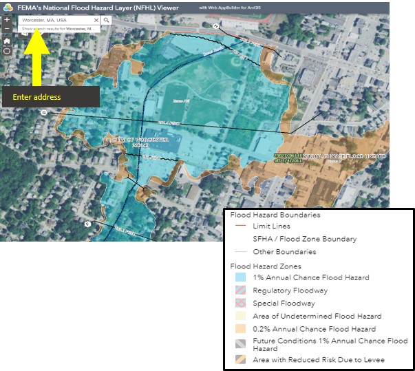
- High risk flood hazard areas. These SFHAs are shown as blue shaded areas, requiring flood insurance for properties with government-backed mortgages. FEMA has mapped these areas as a benchmark for determining when flood insurance is needed/required and the data used is based on historic weather events and past storms data, that are not taking into account observed storm increase caused by climate change. A 100-year flood DOES NOT mean that size storm or flood will occur only once in 100 years. The term DOES mean a flood of that magnitude has a 1% chance of occurring in any given year. For example, areas with a 1% annual chance of flooding have a 26% chance of flooding over the life of a 30 year mortgage!
- Medium and low risk flood hazard areas. Orange/Brown shaded areas show the historic 500 year flood, or 0.2% of that flood occurring any given year. Building in these areas does not require FEMA flood insurance, but cautions property owners in those areas about future potential flooding risks. As climate change brings more frequent and heavier storms, this larger “500 year” floodplain may become the “100 year” flood.
However, just because your home or building is outside the FEMA’s high risk flood hazard area, it does not mean that your property is not at risk of flooding! In fact, many flood-related complaints within the City of Worcester occur outside those areas. Check out the Worcester Flood Mapping Viewer first, to see if there were reported floods in the recent past. If so, check out the resources provided below on how to prepare your property for the next flood event.
FAQ:
I checked FEMA maps and my property is not in the regulated FEMA’s high risk (1% annual chance) flood hazard area. Should I not worry about flooding for my property?
Just because your home or building is outside the FEMA’s high risk flood hazard area, it does not mean that your property is not at risk of flooding! In fact, many flood-related complaints within the City of Worcester occur outside the FEMA floodplain and the City’s Floodplain Overlay District. Check out the Worcester Flood Mapping Viewer first, to see if there were reported floods in the recent past. If so, check out the resources available that provide information on how to prepare your property from the next flood event.
My property is in the FEMA’s high risk (1% annual chance) flood hazard area, but I do not think it should be. Is there anything I can do about it?
Yes, the property owner can always make a case to FEMA to be removed from the flood zone. This requires filing a Letter of Map Change (LOMC) request. This involves hiring a certified engineer by the property owner who will assess your property elevation in relation to the floodplain elevation. If your property is indeed found to be above the floodplain elevation, you can use the LOMC process to petition for your property to be removed from the AE map. Visit the FEMA website for more information.
What does flood insurance cover and not cover?
Check out this resource- https://www.consumerreports.org/flood-insurance/what-flood-insurance-does-and-does-not-cover/
What is the City doing to address the current infrastructure limitations?
Existing storm water infrastructure is aging and its conveyance capacity is limited. Planned replacement/upgrades to the separate stormwater system as well as combined sewer system assets are evaluated and prioritized within the City’s Integrated Water Resources Management Plan.
What can I do to make my property less vulnerable to flooding?